My Smart GPS7x+
Smart Survey GPS power in the palm of your hand
Are you stuck with your EXPENSIVE handheld GPS not able to send or receive your points of interests to your company or associates? Is your hand held or mountable GPS unable to store large databases of collected data? Or do you need several GPS models to full fill your work requirement?
It’s a smart world today. TVs have turned smart, Phones have turned smart, Homes have turned smart and even cities are going smart…so why not your GPS? Standard hardware based GPS accuracy is 15 meters, but GPS in Mobile phones also combine GPS accuracy with cell tower, GPRS, AGPS and WiFi signals to help get a more precise location. So now is your chance to chuck your dedicated GPS hardware and move to the inventive world of powerful smart GPS.
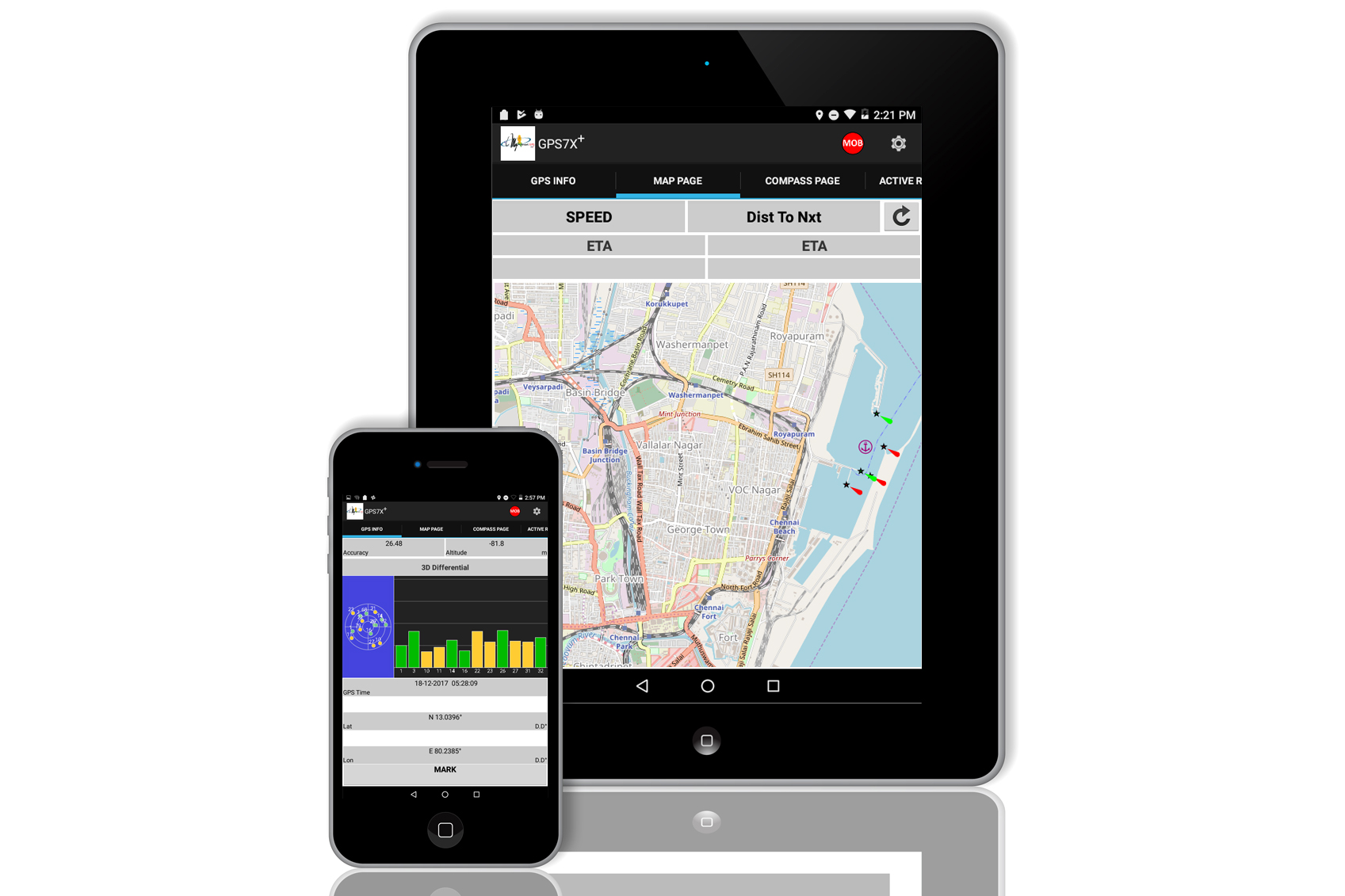
MySmartGPS7x+ combine the best of both worlds namely GPRS and GPS. With user friendly interface designed for enhanced user experience it improves the usability, accessibility and ease of interaction between the user and the product. The GPS7X+ is ALL the popular GPS models packed in one powerful android app. You can use it on your existing phone or a dedicated phone for this application. IP67 rugged option also available
Mysmart series of GPS7x+ is a powerful smartphone Android App, that exceeds the specifications of most high end and popular hardware based hand held GPS units currently available in the market. This powerful smartGPS combines the power of the best GPS in the market and adds the versatility of today’s 3G& 4G cellular networks. This enables the user to sync collected data in real time with his office or user groups from anywhere as long as they either have a 3G/4G or Wifi network, by email or our smartcloud.
MysmartGPS7X+ App is the perfect tool for the busy surveyor or the amateur data compiler in this very mobile world. It is also cost effective as you do not have to go back to your office every time you want to download your data like in the case of hardware based handheld GPS devices. MysmartGPS 7X+ App enables you to work at your pace at anytime and conveniently send collected data to user groups by email or through our secure Gcloud Eco-system. You can even take a picture of your point or object of interest and geotag the same which can be stored locally or sent to your user groups by email or the Gcloud. It also gives you both offline and online maps as well as customization of your personal map is also possible.
Features
-
Take Pictures
- Track log
- Preloaded maps
- Offline / Online Maps
- Photo Navigation
- Instant Data Sharing
- MOB
- Area Calculation
- Geotag
- Photo Navigation and more…
- More accurate GPS fix than regular hardware based GPS (due to A-GPS and cell corrections)
- User-selectable waypoint symbols and comments enhance map display information
- Your movement on the screen is smoothened by very fast responsive refresh
- Heading and Position Refreshed every second
- Preloaded with Open sea maps for offline
- Create your own points of interest or fishing zone
- Man Over Board functions
Specifications
- Display – Multi Screen Compatibility
- User Interface – User Friendly
- Camera Feature – Available
- Area Calculation
- Weather Info
- Basemap – Live Map with Satellite & Terrain View
- Data Sharing – Easy Data Sharing Option
- Offline Map
- Online Map
- Compass – Dual Compass Option
- Key Function – Touch
- Ability to Add Maps
- Waypoints – Unlimited
- Routes – Unlimited
- Track Log – Unlimited
- Picture Viewer
- Mark Icon ( add on waypoint )
- Photo Navigation
- MOB